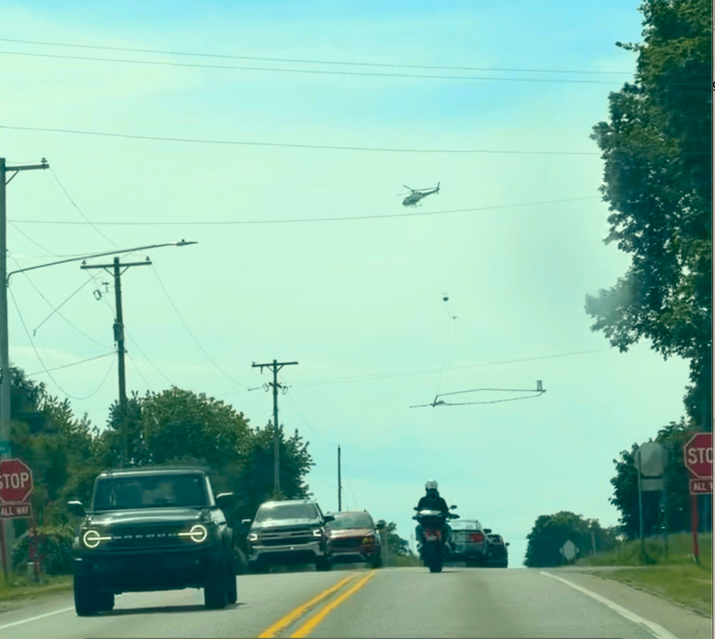
Looking like some kind of a futuristic cow-herder, the US Geological Survey (USGS) helicopter hovers above a hexagonal sensor that essentially x-rays the ground below. Working with the EGLE (the Michigan Department of Environment, Great Lakes, and Energy), USGS is performing an airborne electromagnetic survey (AEM) of regional aquifers and geology.
The helicopter set out in April of this year, and having made it to Ottawa County, appears to be nearing the end of its course. A live tracking map shows the ground its covered to date. Recently, the helicopter has been spotted in Ottawa County.
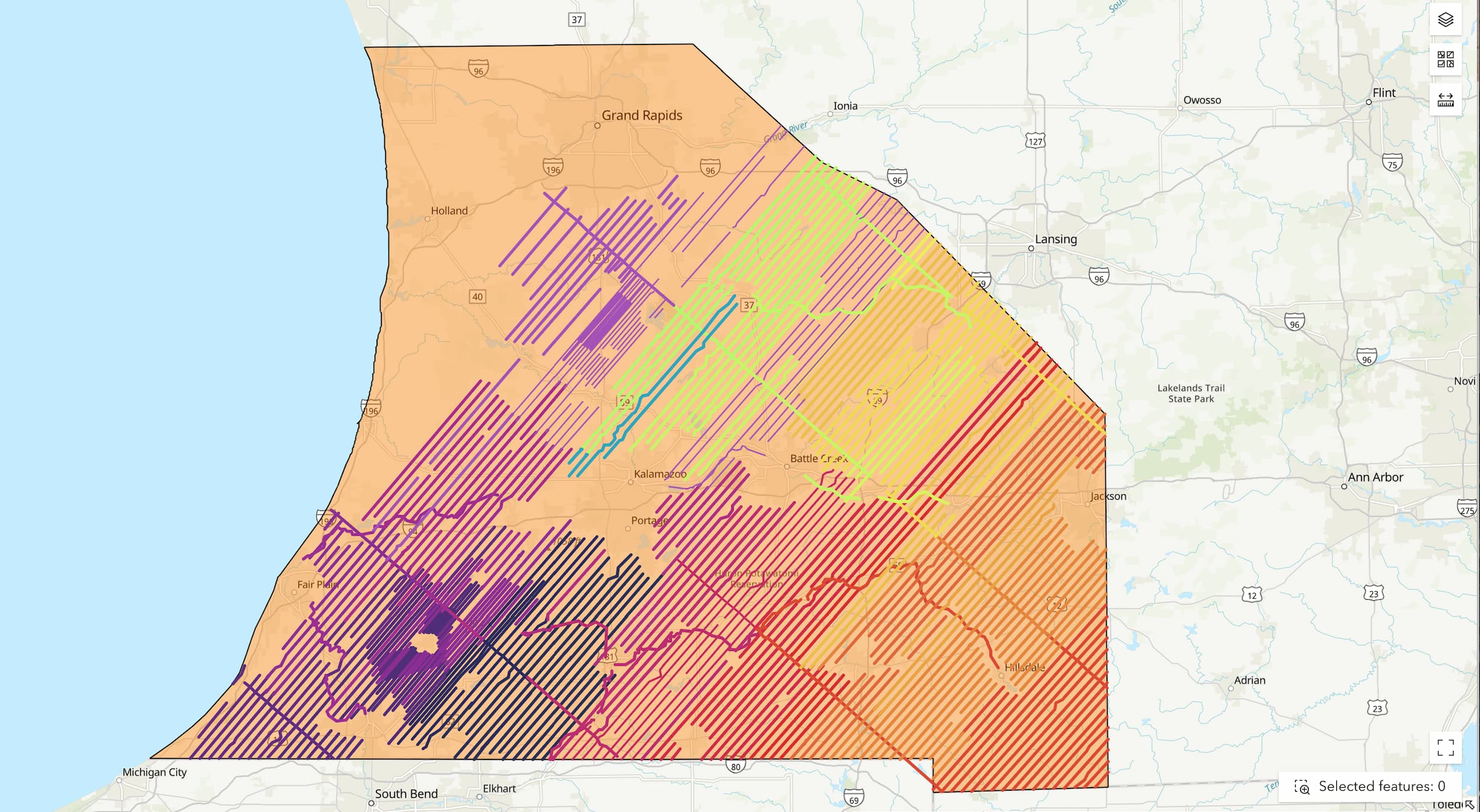
Because of major groundwater quality and quantity challenges, the Ottawa County’s Department of Strategic Impact (DSI) has requested denser flight lines than is typical—so that the data will be more detailed and of higher resolution and allow the department to better understand the situation underground.
The added cost to Ottawa County for the increased AEM density is about $78,000. EGLE will pick up roughly $19,500, and the remaining $58,500 will be covered by groundwater grant funds. Once the data is collected, USGA and EGLE will process and interpret the data. The entire, exhaustive effort is expected to take well over a year.
At a recent Ottawa County Groundwater Board meeting, Sara Pearson, Source Water Unit Supervisor for EGLE, explained that the time and resources Ottawa County already has spent logging wells will positively impact the AEM and enhance the accuracy. She said that the work DSI has done drilling through the glacial package down to the bedrock, “sets some really nice calibration points” that USGS can use to create an even better 3-D model.
The idea behind the AEM, Pearson said, is to get a better handle on what the aquifers look like in the subsurface and to understand groundwater quantity. Since the sensor won’t be able to see every nook and cranny, she said the results won’t be perfect. But the models will give a better perspective than what currently is available.
The other counties being surveyed include Muskegon, Kent, Barry, Allegan, Kalamazoo, and Van Buren.
Matt Chappuies, Ottawa County Land Use Coordinator, explained that Michigan is way behind the curve in terms of groundwater resource data. Many other states either have performed more studies, have a lot more monitoring wells, or have different data points that indicate the condition of their aquifers.
Michigan is trying to catch up and “get a better picture of what's happening beneath our feet” and improve data quality.
While the other counties being surveyed do have groundwater issues, they're not necessarily the same or to the extent of what's happening in Ottawa County. And other counties, as far as Chappuies knew, really aren't investing in trying to understand or address the issues to the level that Ottawa County is.
“The geology here is very unique,” Chappuies said. “And the limitations that we have are pretty unique.”
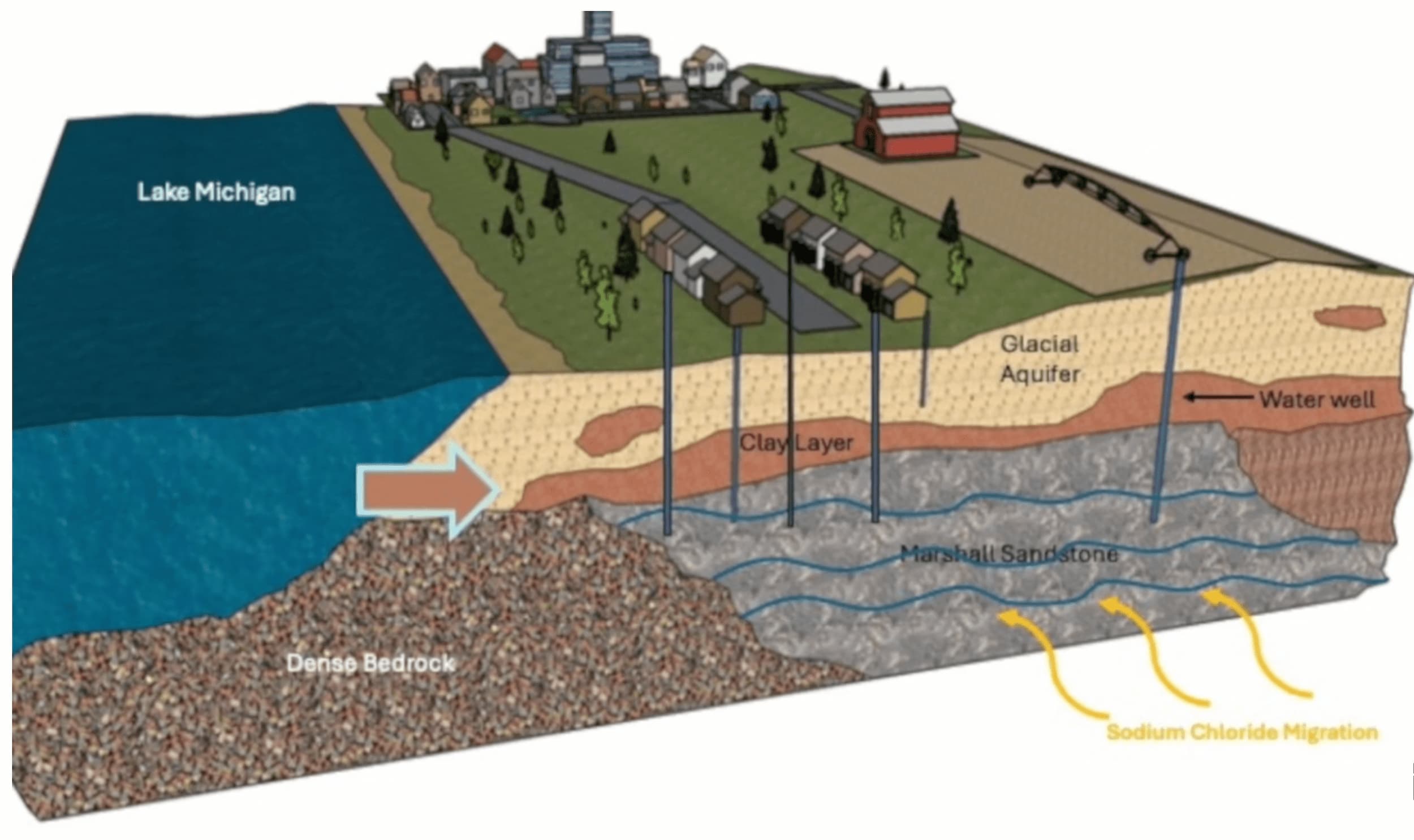
Chappuies explained that the core of the issue is that there is a big layer of clay that sits on top of the county’s aquifer, preventing it from recharging the way a normal aquifer system recharges—from rain or snowmelt soaking into the ground.
Because the clay is so close to the surface and doesn't let water seep into the ground, Chappuies said there is a lot of standing water and flooding happening. DSI has been looking into "force" recharge which can be done with injection wells. However, that may not be a viable option.
“There’s a misconception,” Chappuies said, “that we have all this water. It’s surface water everywhere.” He explained that the problem is that the water is not connected, not filling our aquifers. A lot of people pull from the Glacier aquifer system. But for most of the central portion of the county, the Glacial aquifer system is very shallow—sometimes only a few feet deep—which results in the clay being too close to the surface.
Since the law requires that a well be a minimum of 20 feet to avoid getting contaminants into drinking water, where the Glacial aquifer system isn’t deep enough, a well must go through the clay and down into the Marshall aquifer, a bedrock formation.
The Marshall is restricted from refilling because it’s cut off from Lake Michigan and other freshwater resources. According to DSI Director Paul Sachs, the Marshall is full of ancient water, and it can take 10 to 20 years for water to pass through the clay layer to recharge naturally. Sachs added that Ottawa County is pulling more water out of the Marshall than can "concurrently be naturally recharged."
Pearson said that the goal is to be able to create a dashboard of hydrologic data for local leaders to use to see what the precipitation, water use, and stream flow look like and then be able to consider that with the land use, population growth, and population predictions in their area. The data will help with creating a water budget for long-term planning.
For Ottawa County specifically, Chappuies said policies are being considered on where developments should go and where new wells should be placed or not placed. With the correct data to stand behind decisions, it will be easier to create new policies and provide a better understanding of what’s happening.
Chappuies explained that Michigan law is structured in a way that groundwater is a shared resource that local governments, and even state governments, don’t have control over. There are some exceptions when it comes to large quantity withdrawals, such as for larger farms and different operations, which have to follow a separate regulatory process.
But for the most part, Chappuies said local government doesn’t have the authority or ability to tell people what they can do with the water that's beneath them.
Though sometimes, Chappuies explained, townships have to take a creative approach and adopt zoning ordinances, for example, that require large housing developments to use city water. The zoning process is often the only option for impacting what’s allowed to be built.
By providing an understanding of the hydrogeologic conditions, Pearson said the AEM could help predict how the groundwater systems will respond to different impacts, such as to data centers or other large users. The AEM will be one more component to be aware of in “the overall data picture that's put together by federal, state and local levels trying to understand what what's happening with our water,” she said.
When asked if a data center with known water demands would be able to be built in Ottawa County, Chappuies wasn't sure but thought one “would almost certainly have to connect to a municipal water supply because there isn’t a lot of groundwater to pull from.”

Krista Yetzke is a native of Ottawa County. A jeep-driving, guitar-playing wife, mom, and everyday adventurer, Krista was raised on the love of Jesus, the great outdoors, the arts, the value of frugality, and the beauty of food as medicine.
Copyright © 2025 Hollander Media. All Rights Reserved. This material may not be published, broadcast, rewritten, or redistributed without written authorization. By providing your email or phone number, you are consenting to receive emails, calls, and SMS/MMS messages from The Hollander and affiliates. Msg & data rates may apply.